Background
The mission of the OpenStreetMap (OSM) and U.S. Government Committee is to seek out mutually beneficial relationships between the public and open data communities. As part of this effort, OSM community members and representatives from federal agencies have been investigating solutions for feature collection that would result in data being contributed to both the OSM community, and back to the federal government as public domain. Committee participants are pursuing a demonstration project to collect railroad tunnels for official government use.
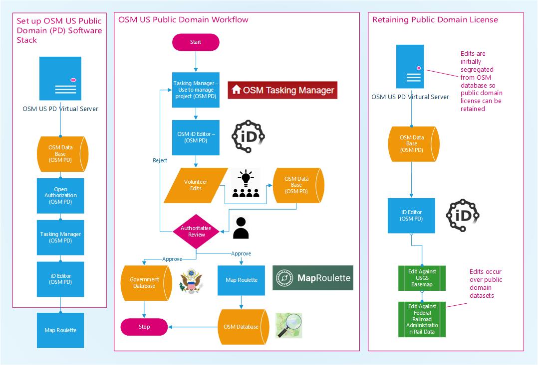
How it Works
Two of the most dreaded words in the OpenStreetMap community are “Licensing” and “Imports”. There are a lot of opinions on how these issues should be handled since they deal with varying legal issues across jurisdictions and imports can disincentivize some contributors.
This project aims to keep licensing out of the picture entirely by focusing only on public domain data. All imported data will come from sources that are in the public domain and all contributions will remain in the public domain. This will allow the original public domain datasets to accept edits from users. It will also allow the edits to be applied to OpenStreetMap.
The contributions will not be directly imported into OpenStreetMap, but will go through an authoritative review process using tools from the OpenStreetMap ecosystem such as MapRoulette and Tasking Manager.
What about public domain requirements and ODbL?
It’s a “oneway=yes” workflow from public domain to ODbL. Public domain contributions can be applied to OpenStreetMap directly, where the copy on the OpenStreetMap server will become licensed as ODbL. The original contribution is maintained in a 100% public domain database that can be used for any purpose.
Examples of systems that cannot use ODbL data, but can use public domain, are the U.S. federal government and closed-source mapping products, such as Google Maps.
The Need it Fills
The OpenStreetMap tools are very well designed and provide an excellent system for other crowdsourced projects. Licensing is a tricky issue and this project aims to sidestep it by focusing on public domain data exclusively.
OpenStreetMap provides flexible tools that can be used to verify quality and accuracy by having either an authoritative agency or a second reviewer validate submitted work. This same two step process has been in use for over a decade by the U.S. Geological Survey’s The National Map Corps crowdsourcing program to ensure National Map Accuracy Standards are met.
The dataset resulting from this project is available for anyone to use and is free of any license and can also be used as a data source for OpenStreetMap.
The Design View
Why are we doing this?
If the OpenStreetMap and U.S. Government Committee can demonstrate the ability for government agencies to collect official data in the OSM mapping environment, this will greatly increase the number of volunteers available to collect official government data, improve the functionality of software used to collect data, and could allow crowdsourcing infrastructure to be moved from government systems into more flexible and less encumbered systems with oversight by nonprofit communities. These changes would broaden the horizon for future data collection within the federal government while allowing volunteers to contribute data that is more current and readily usable by government agencies.
How you can get involved
- OSM US:Slack: #publicdomainosm
- Github: https://github.com/publicdomainmap
What’s Next?
The team investigating these solutions is still early in the project development life cycle and only focused on a basic proof of concept. Pending the eventual success of the demonstration project, we would like to expand involvement to other agencies, add data themes, and focus on setting up robust and efficient software solutions that enables the collection of verified and public domain data for both OSM and government agency use.